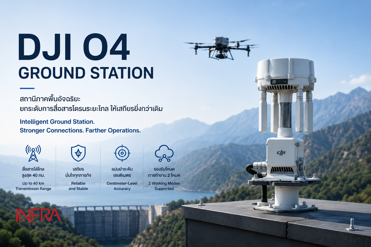
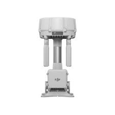
• About us
  • Product & Services
Please type the word you want to search for
Leading Innovative
Solutions For Sustainable
Infrastructure

Our Products

Categories
Product Categoreis en
Romdas – Right of Ways Video is utilized for capturing footage of the right-of-way (ROW) to collect data regarding road assets and inventory. Users have the option to select either a single high-resolution ROW camera or a 360-view camera. The quantity of single ROW cameras can be tailored and modified according to project specifications.
Create a log of footpath surfaces for visual assessment. A single camera installed vertically at the back of the vehicle is sufficient to cover the lane width and provide real-time road imagery. These images will help detect and measure the most common defects affecting office safety.
The Romdas High-Resolution Distance Measurement Instrument (HR-DMI) is used in projects requiring highly accurate distance measurements (<0.1 m). The robust encoder can be programmed from 360 to 10,000 pulses per revolution, depending on the application.
The Romdas bump integrator is a Class 3 responsive-type road roughness measuring device used for assessing road roughness on non-paved roads. Over the past two to three decades, the bump integrator has been widely used in countries with varying weather and road conditions. It is a cost-effective option for roughness measurement and IRI calculation. The bump integrator excels in roughness measurement, particularly on unpaved surfaces or in wet road conditions.
The Romdas video logging module records both roadway segments and surface images, allowing users to define continuous image capture. Additionally, real-time viewing during data collection enables continuous quality checking and control. Settings can be adjusted for font, size, and color to maximize readability and clarity. Furthermore, camera upgrades are available to capture both roadway segments and surface images. The software is specifically designed for data collection and processing.
The International Roughness Index (IRI) assessment criteria adhere to Laser Class I standards and comply with ASTM-E950. It involves a combination of laser and road height measurement. The profiles are analyzed to calculate the International Roughness Index (IRI). The portable system can be used to survey large-scale highway construction networks, providing highly accurate data. Its design allows for customization as a single or dual-laser system, depending on customer needs.
Vehicles equipped with technology for road condition assessment use laser-based crack measurement systems and advanced options to create high-resolution three-dimensional images. The equipment supports widths of up to 4 meters of traffic lanes and can operate at normal traffic speeds, both during the day and at night.
Vehicles for road condition assessment using technology are utilized to measure and evaluate profile values along the cross slope. They employ 17 high-quality ultrasonic sensors and 4 laser sensors to ensure high-touch points, resulting in high-quality cross-slope profiles. This method is the most cost-effective and efficient way to gather current wheel rut depth data. However, due to tool upgrades, there has been a shift from ultrasonic sensors to laser sensors. These laser sensors offer high accuracy, while the basic equipment remains the same, providing great value for the price.
Trimble - X7 The Trimble® X7 3D laser scanning system delivers fast and accurate results every time for surveyors and geospatial experts. This compact and easy-to-use scanning device ensures confidence in every location.
The Grip Tester MK2 is a trailer-based continuous friction measuring device that operates on the principle of measuring the skid resistance of a surface against two drive tyres. The obtained GripNumber is transmitted to a computer in the control room. This device is flexible, precise, and cost-effective.
The system, designed to comply with standards and serve as a street lighting mapping system for assessing the quality and efficiency of internationally standardized lighting installations, is a versatile application that can be installed in various forms, including handheld devices, bicycles, and cars. It is suitable for driving at speeds of up to 100 kilometers per hour and comes with high-speed digital sensors, high-performance GPS modules, and optional car consoles and HD video cameras.
Currently, various agencies have recognized the importance of the reflectivity of road markings in relation to road safety. These agencies have begun assessing and managing road markings on all roads. The Laserlux G7 is a safe and easy-to-use tool designed to meet these needs. The Laserlux G7 can evaluate road marking reflectivity without requiring traffic closures or vehicle modifications for operation.